Above the Arctic
Circle:
The Lofoten (Norway)
February 10 - 15, 2020
(updated 1/2/2021)
(click your browser's "back" button to return
to original location
or click here to go to David Boston
Photography)
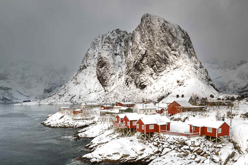
Rorbu in Hamnřy, with Festhaeltinden (elev 1276 ft) in the background, as seen from the Hamnřy Bridge
|
View
the slideshows by clicking
When
finished, click your browser's
|
Introduction. Lofoten is an archipelago and a district in the county of
Nordland, Norway. It’s known for a distinctive scenery with dramatic mountains
and peaks, open sea and sheltered bays, beaches and untouched lands. Its capital
and largest town, Svolvaer, lies approximately 105 miles inside the Arctic
Circle, or approximately 1,390 miles away from the North Pole, thus making
Lofoten one of the world's northernmost populated regions. Though lying within
the Arctic Circle, the archipelago experiences one of the world's largest
elevated temperature anomalies relative to its high latitude. Lofoten features a subpolar oceanic climate; therefore,
winter temperatures are very mild considering its location north of the Arctic
Circle – Lofoten has the largest positive temperature anomaly in the world
relative to latitude. This is a result of the Gulf Stream and its extensions:
the North Atlantic Current and the Norwegian Current. Rřst and Vćrřy are the
most northerly locations in the world where average temperatures are above
freezing all year. In February 2020, I traveled to Norway to meet up with good
friend Andy
Lerman to participate in a photo workshop led by John
Pedersen and Örvar
Ţorgeirsson. Joining us were
two other photographers, Steve
Butterworth (another friend of Andy’s) and Bill Glass. Working out of two locations, Leknes and Reine, in the Lofoten, the six
of us worked well together and enjoyed exploring and photographing the stunning
scenery of the Lofoten. Updates:
Photo info. Click the slideshow icon at left to see the photos from the trip. The following equipment was used:
All images were shot RAW (5DMKIV & 7DMKII) or JPG (Moto Z4) processed in Adobe Photoshop Lightroom Classic CC with occasional touch up in Adobe Photoshop CC. Additional photo data is provided below each photo in the slideshow. Enjoy the photos! Unless indicated otherwise, all photos are Copyright © 2020 David W. Boston |